The Mighty Amazon
“The Mighty Amazon” from Brazil and the Brazilians by George James Bruce, 1914.
From: 1914 C.E. To: 1914 C.E.
Location: Amazon River, Brazil
Note: This article has been excerpted from a larger work in the public domain and shared here due to its historical value. It may contain outdated ideas and language that do not reflect TOTA’s opinions and beliefs.
“The Mighty Amazon” from Brazil and the Brazilians by George James Bruce, 1914.
Far up in the Peruvian Andes, sixteen thousand feet above sea-level, there is a little lake called Lauri-Cocha. It is only about three miles across. From the peaks above it you can look down on the Pacific Ocean near Callao. Out of the lake trickles a tiny rivulet that gets no other name but Lauri-Cocha till it has gone a long way. Looking at the cold blue lake and the puny stream issuing from it, one can scarcely realise here is the source of the mighty Amazon. Away down the mountainsides tumbles the rivulet, disappearing here and there to reappear farther on.
The streamlet, gathering strength from melting snows and other rivulets joining it, becomes a mountain torrent. Leaping from rocks into cañons, it dashes on its way, coursing through gloomy ravines, foaming as it struggles over boulders and around impeding tree-trunks. With a roar of exultation it sweeps over precipices, down ever down towards the great mountains' base. Torrent and valley stream rush to support and strengthen it.
Away through the mountains it tears, increasing in volume till, no more a mere mountain torrent, it leaves behind its birth-name and becomes the Marañon River. Winding in and out amongst the mountains, the river seems to be seeking an outlet through some grand cañon to the Pacific. For hundreds of miles it flows northward, till, when one would expect it to find some way through Ecuador to the Gulf of Guayaquil, it flows gradually north-east.
As if weary of contending with the mountains on the west the river turns forever away from the Pacific and, though it means traversing a vast continent, decides to reach the Atlantic in the east. To get through the Cordilleras the Marañon has to rush through the famous Pongo of Manseriche, a gorge five or six miles long, almost covered by overhanging rocks. Soon after issuing from this it is joined by one of the great rivers of Ecuador, and then by the Huallaga, which had its source near that of the Marañon but had gone eastward from Huanucu.
Before reaching Iquitos the Ucayali River pours its waters into the Marañon, and ere the Brazilian frontier is reached many important affluents from right and left have added their quota. The most important of these is the Napo, from which the entire river was first navigated. At the Brazilian frontier the river again changes its name and becomes the Solimoēs.
Amongst the many great rivers that join it as it enters Brazil are the Javary, Putumayo, Jutahy, Jurua, Japura, Teffe, Coary, and Purus. All these are navigable by steamers for hundreds, and some of them for thousands of miles. The little child of Lauri-Cocha has become a gigantic waterway, rolling through thousands of miles of wonderful tropical forests, bearing the commerce of nations on its golden waters. Soon it reaches a most important point in its journey to the Atlantic.
The Rio Negro, that mysterious river of El Dorado stories and sombre water, adds its huge volume to the Solimoēs. Thus, a few miles below the city of Manaos we have the most interesting river junction in the world. The Rio Negro connects in the south-east of Venezuela with the River Orinoco, and the River Madeira, flowing into the Amazon a few miles from the Rio Negro junction, connects in the south-west of Matto Grosso with the Paraguay.
The Orinoco is a great water highway running north, the Paraguay running south, and the Amazon east and west across the continent. So that from Manaos a traveller may go north, south, and east by water and reach the Atlantic Ocean, and also reach a point westward a short distance from the Pacific. There are of course waterfalls and rapids to be negotiated, but except for a few miles of these, this marvellous water-system may be utilised to traverse a continent from north to south and east to west. Someday it will be the ambition of travellers to have this record to their credit.
At the junction of the Rio Negro with the Solimoes an interesting circumstance may be seen. The water of the Solimoes is a golden yellow, that of the Rio Negro an inky-black in appearance in the river, but resembling strong tea in a glass. When the Rio Negro strikes the Solimoēs there is a contest for right-of-way, and many large whirlpools are formed where the waters come together. The heavier yellow water of the Solimoes prevails, and the murky, lighter water of the Rio Negro seems to be completely held up. It is a curious sight to see two large bodies of water in contact with each other, yet remaining distinct in appearance and qualities. Of course these waters do actually blend, though their doing so is not apparent.
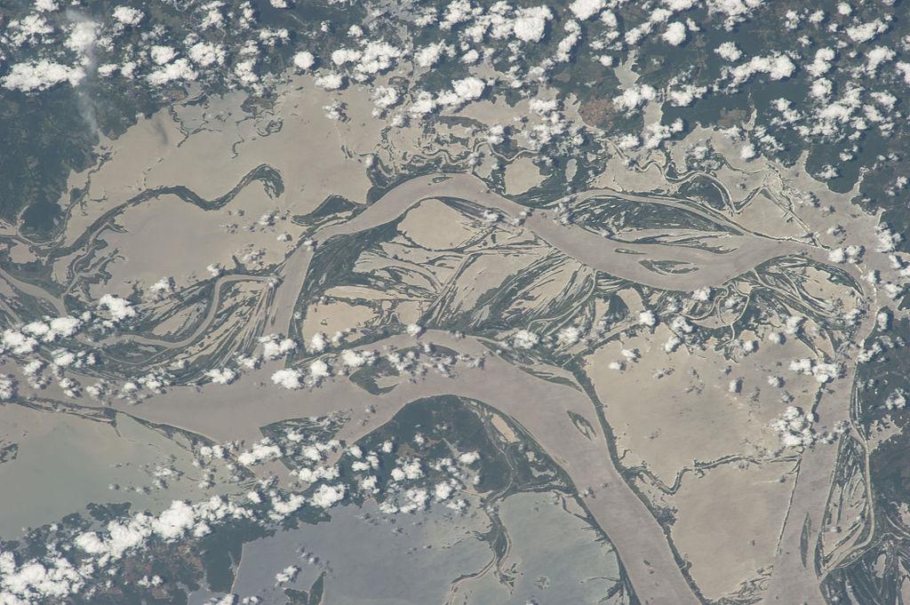
The Solimoēs draws the darker water away with it somehow, while retaining its own original tint. From this junction onward the river is known as the Amazon, so that in its course of 3850 miles it enjoys four names—Lauri-Cocha, Marañon, Solimoēs, and Amazon. When, a few miles from the Rio Negro junction, the Madeira, that great river from the south, adds its volume, the Amazon becomes incomparably majestic. Plains disappear to become but one vast riverbed. Hills are left behind as mere islands dotting the surface of the widespread flood. The Amazon soon reaches a width of sixty miles and a depth of 1500 feet. Islands larger than principalities in Europe are created by its refusal to be confined to one channel.
River after river from north and south pour their waters into the mammoth. The Namunda, Mapuera, Maycuru, Gurupatuba, Paru, Jary, and Carapanatuba from the north; the black Tapajoz, the Parintins, Xingu, Uanapu, and Tocantins from the south are the principal contributors. Losing all resemblance to a river, the Amazon continues to deepen and expand, till, when it reaches the Atlantic, it is 158 miles wide and deep enough to hurl into that ocean 500,000 cubic feet of water every second. It is not surprising that the earliest visitors to it named their discovery the Mar Dulce, freshwater sea.
The basin drained by the Amazon and its affluents comprehends an area of 2,722,000 square miles, which is more than double the combined area of the next two greatest river-basins in the world.
The Amazon river system, including affluents and sub-affluents, as far as explored, extends over a length of 50,000 miles. The depth of the river varies from 200 to 1700 feet. The current is slow, usually not more than three or four miles an hour, the average fall being only about a foot in nine miles, in Brazilian territory. In flood time it rises up to 60 feet above its normal level, even a thousand miles from its mouth.
The river reaches its maximum height in June, and is at its minimum in December. The ocean tides affect the Amazon as far up as the city of Obidos, 581 miles from the mouth. The river has about 200 affluents in Brazil. Of these six are larger and longer than the Rhine, and twelve others may be classed as rivers of first-class importance.
The river is navigable by ocean-going steamers to a point about 3000 miles from its mouth, or about the distance from Liverpool to New York. Its main affluents are also navigable for distances up to a thousand miles from the Amazon. The extent of waters navigable by small steamers in the Amazon Basin is estimated to be 40,000 miles. There are many thousands of islands in the Amazon. The largest are Marajo in the mouth, about 200 miles long, and Tupinambaranas, about 700 miles from the mouth, which is 186 miles long.
The greatest affluents are the Maderia, 3125 miles long, navigable by ocean steamers 658 miles; the Purus, 2268 miles, navigable 1118 miles; Japura, 1740 miles, navigable 1000 miles; Rio Negro, unexplored properly beyond 1200 miles, navigable 451 miles. The Purus and Japura are navigable by small steamers for over 1500 miles. Perhaps the most striking of these affluents is the Rio Negro, which at Manaos is 1 ½ miles wide, while farther up, for hundreds of miles, its width varies from ten to twenty-five miles. It has innumerable islands, all densely wooded. Some of these are thirty miles long and unexplored.
The Rio Branco, a river of clear water with a whitish tint, is an important affluent of the Rio Negro. In that triangular territory formed by these rivers and the northern boundary of Brazil, it has always been supposed the famous El Dorado lay. From Manaos to the frontiers of Colombia and Peru, between the Rio Negro and the Solimoes, there lies territory tens of thousands of square miles in extent, very imperfectly known, studded with precious stones and valuable minerals. Hundreds of rivers, many of them apparently navigable by ocean steamers, come out of it to the Rio Negro. The country is densely clothed with forests that may yet supply Europe with a large proportion of her paper and timber requirements. It might with justification be held that the Amazon Valley is the greatest timber area in the world left unexploited.
These great forests, with their almost endless varieties of woods, are the most accessible timber areas known. They are intersected everywhere by navigable rivers, most of them usable all the year round. The possibilities of discovering mineral wealth should be an attraction, even if there were not wealth enough already in the millions of seringa and caoutchouc trees yet untouched.
Going up the Amazon and Purus from the Atlantic to the Federal Territory of Acre, in the farthest west corner of Brazil, we must cross first the State of Para and then the State of Amazonas. We enter the river at Point Taipu below the city of Belem or Para, the capital of the State of Para. Steaming up the estuary, we find the city on the left bank. Ocean passenger steamers usually tie up here, and before proceeding take a river pilot on board. Should time be no object and personal comfort not a sine qua non, a change might be made into one of the smaller river-boats that call at every town on the river. It is advisable perhaps to stick to your ocean liner as far as Manaos at least.
The first hundred miles or so from Para is not extremely interesting. You steam over a wide expanse of water with views only of far-away shores. Gradually, however, the shores converge, and the steamer enters a narrow passage that would be like a canal were it not for the giant trees and dense undergrowth on either bank. A hundred miles of this and the town of Gurupa is reached. Breves was passed as we entered the narrow part. At Gurupa we are fairly into the Amazon, and we are struck with the number and size of the islands passed.
The mouth of the Xingu is crossed, and the steamer is soon abreast of the town of Prainha on the north bank. From there we go on, noticing Mt. Allegre through our glasses with its town 1000 feet above the river, and soon arrive at Santarem, a town of importance at the mouth of the Tapajoz. Santarem has a population of 30,000 and is a town with many fine buildings, including a theatre, market, and several fine schools. It is the commercial centre of a farming and stock-raising district.
Several small villages are passed ere we reach Obidos, another town of considerable size on the north bank. It has a population of about 40,000, with several good streets and up-to-date buildings. It also is a stock-raising centre and noted for its carriage horses. The next town of note reached is Parintins on the Amazonas frontier. This is a fast-growing town of 20,000 inhabitants which, from its situation at the junction of the Maues River, is likely to become a great trading centre one day.
As the steamer ploughs its way onwards, we often almost lose sight of the banks. They are so far away. At times too we can break twigs from overhanging trees as we seem to brush along the shore of some island. The farther we go the more interesting does the scenery around become. Some mornings we come on deck to see chains of hills stretching away from the narrow plain between them and the river.
Then we plunge into the dense forests again to startle the brilliantly plumaged birds that fly off at our approach. Some of these will sit on the trees and look curiously down at us, possibly wondering why this intrusion. A troop of monkeys are surprised as they have come to the river-bank, perhaps for their morning dip. The way they scamper off, swinging from branch to branch, uttering sounds of terror, is wonderful to behold. Every bend of the river we round reveals fresh glories of nature.
Hanging from gnarled giants of the forest, like flowing tresses, are strange, flowering creepers, swaying in the breezes, or stretched from tree to tree in fan- tastic devices. Here and there the whole forest seems roped together with bright, living garlands of angels' weaving. The pale-green, tender-looking shrubs seem to nestle up to the strong, dark-green trees beside them. Every conceivable arrangement of tree and plant grouping of colour and shade studies, with an unimaginable diversity in character of trees, shrubs, and flowers, pass in review before you.
It is a botanical banquet. And you can enjoy it all lying at your ease in a deck-chair on a modern ocean liner. Pages might be occupied trying to paint in words the glories of a trip through this wonderland, but no adequate conception would then be given. The tropical forest scenery of the Amazon must be seen to have its indescribable beauty fully realised.
Itacoatiara, on the north bank, is the last town of any size we will see before reaching Manaos. On the opposite bank is Ramos, a town on the island of Tupinambaranas. An attempt is being made to make Itacoatiara the point of departure on the Amazon for the towns on the River Madeira and its affluents, but owing to the proximity of Manaos, where a great deal of money has been spent on port equipment, this is not likely to succeed till at least as much money is spent on Itacoatiara. A railway connecting this town with Manaos was once actually begun.
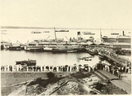
Our first glimpse of Manaos after we have entered the Rio Negro is got at a distance of five or six miles. One who has not carefully read up is scarcely prepared for the scene we approach. Almost a thousand miles up the river we enter a port where we count fifty steamers and three gunboats, besides a flotilla of small craft, lying at wharves or in the stream. Several of the steamers tied up to the wharves are trans-Atlantic liners; some of those in the stream are cargo tramps.
On the north bank appears a city with cathedral and church spires penetrating the sky-line. Amongst the prominent buildings we notice at least one sky-scraper nine or ten stories high, and many other fine modern erections. Large steel bridges cross arms of the river, electric trams, taxi-cabs, and motors are rushing about finely paved streets. But we cannot stop just now to mention the many things that astonish us in this pivot city of a little-known continent. We transfer from our ocean liner to a river boat and return a short distance to get into the Solimoēs on our way to Acre. We are soon steaming up that river on our long journey to Senna Madureira, the capital, on the Yaco River. It took us only four days to travel the thousand miles from the Atlantic to Manaos.
It will take us just about a month, with the numerous stoppages, to travel the 2000 miles still before us, but we get snug quarters in a British steamer for the greater part of the way, so we are satisfied. As we throw behind us hundred after hundred of miles, we seem to be getting into denser woods, and the vastness of the Amazon forest regions begins to appal us. Day after day, week in and week out, we steam through those countless millions of trees. Sometimes we have a spell of open country. What a relief it seems to see nothing but bare ground! We have halted for hours at river settlements, and tied up at nights in many strange places.
The few villages hidden away in these forest depths are roused to activity on our approach. We carry their mails and stores. A thousand miles between us and Manaos and we realise we are in the heart of the greatest seringa region of the world. Steamers laden with seringa balls like giant footballs meet us continually. They are all on their way to Manaos with their valuable cargoes.
Along the river banks we can see the hevea trees in numbers, and occasionally we see a seringueiro on his rounds seringa-collecting. At length we must change our steamer again, and do the last few hundred miles in a modest little craft, for the river is not yet at its maximum height. Just a few miles from the southern boundary of Amazonas we leave the Purus and enter the Yaco. Villages and settlements are more frequent, and the river is busier. Senna Madureira is reached at last, and we are glad to tramp down its long street to our comfortable quarters.
The town, which is the capital of Acre, has a population of about 5000 when its residents are all in from the forests. This is not often, however. There are no striking buildings erected yet, but the town is the youngest capital in Brazil. It is only a few years old, yet it has had its revolution, owns a newspaper, club, amusement halls, and many business houses. One soon forgets, while enjoying the hospitality of its amiable citizens, that you are actually in one of the most remote corners of any civilised country, thousands of miles up in the hindermost of all back blocks. Acre has several rapidly growing towns on its numerous rivers; and every year its people are bringing fresh areas of seringa forests into working. This corner of the Amazon Basin is at present one of its greatest wealth-producing areas.
Bruce, George James. Brazil and the Brazilians. Dodd, Mead and Company, 1914.
About TOTA
TOTA.world provides cultural information and sharing across the world to help you explore your Family’s Cultural History and create deep connections with the lives and cultures of your ancestors.
